


2022 Summer Trail Plans
This is me holding myself accountable to actually pursue the things I want to do in life

What do Patagonia Baggies, picaridin, river baths, sunburns, and Teva sandals all have in common? That’s right, it’s summer! Time for sticky, sweaty nights snoozing outside of your sleeping bag and attempts to plan trips around Midwest heat advisories. Or if you’re like me, you hike anyway in 90-degree weather and suffer the entire time voluntarily, but that’s a story for another time.
Every summer I organize these elaborate backpacking trips that I get all excited about that never end up happening because life gets in the way or I feel guilty for taking off for work. Not this time! Nope, this year Callie is going to prioritize adventure and playtime in the woods. If everything goes as planned, this could be a pretty awesome summer. So, to hold myself accountable I’m going to visually state my intentions for all to see in this post, and hopefully, when unexpected life pressures pop up and I feel obligated to people please, I am going to put myself first for a change.
Going back to Cali

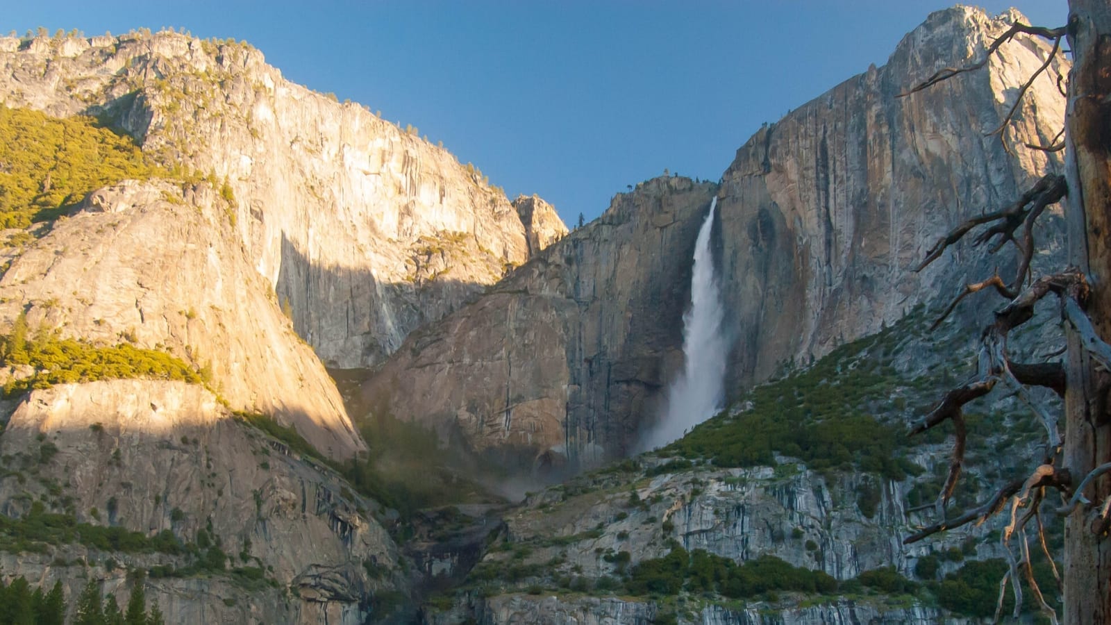
I have three main goals or trails I want to complete this summer, each of them is challenging in their own way and have been in the back of my mind for a while now. The big one I’m beyond thrilled about is a three-day backpacking trip on the North Rim Route in Yosemite National Park. This Appalachia-born, now Missouri suburbian has never been to California, so I’m stoked…and also terrified! This will be my longest road trip and while I’m planning on taking someone with me, it’s still nerve-wracking planning a trip of this magnitude when they’re so many moving parts involved.
I will say that getting backcountry permits were not as difficult as I thought it would be. All Yosemite permits can be reserved through Recreation.gov. This is also where you can put your name in the lottery for the John Muir Trail thru-hike or Half Dome day hike as well. I simply searched for available entry point locations within my designated dates and secured the permits from there. The permits only cost ten dollars for two people as well, so they were very affordable.
I also had to submit where I intended to camp each night which got me a little flustered as I’ve never been to this part of the country before and wasn’t prepared to have a detailed itinerary that far out from the trip. But after consulting several maps, I was able to make a decent guess as to which campsites would probably work the best. Backpacking trips are so subjective and rarely go as planned (at least for me), so I’m hoping it won’t be the biggest issue if I deviate slightly from the plan if needed. I will add a side note though that I booked these reservations months in advance and as time gets closer to the busier summer season, permits will most definitely be harder to secure.
The trip is set for the end of July and starts in the less populated area of Tamarack Creek. The original North Rim Route starts on Big Oak Flat Road, but the time slot I wanted for the trip didn’t have any availability there so I decided to start at Tamarack Creek. Despite this, the trail still ends up being about the same lengthwise, which is around 30 miles or so. Since the terrain is vastly different than what I’m used to and has much more elevation change than the flatlands of the Midwest, I decided three days/two nights covering ten miles a day will be realistic. Plus, I don’t want to blow through the entire trail and speed hike the whole thing either. Come on, it’s Yosemite! When am I ever going to be that far west again? So, I want to try and take it in with the time I have.

With the North Rim Route, I will not only get to see epic views of Yosemite Valley but some amazing spots within the park as well. Night one, I’m planning on camping on top of El Capitan, and in the days that follow I’ll get to visit Upper Yosemite Falls, Porcupine Creek, and North Dome. Then I will end the hike by entering the valley on the Snow Creek Trail. While I waited too late for Half Dome day hike permits, I hope that I can secure them in person when the backpacking portion of the trip is over. Because how can I go to Yosemite and not climb Half Dome? Needless to say, I’m extremely excited about this trip. I still have a lot of technical aspects to work out, but half the battle was getting the trip reserved. Now I just wait and nerd out over what gear I’m taking.
Cry me a river
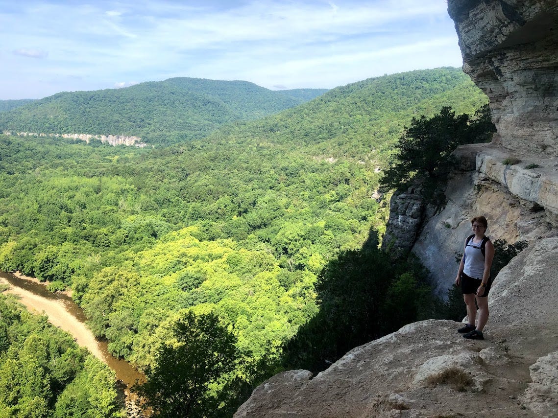
The second adventure I have planned is a backpacking trip on the Buffalo River Trail in Arkansas. The BRT is a hidden gem located within the Buffalo National River area in the Ozark Mountain region of northern Arkansas. The 37-mile trail spans through dense rural woods and thick deciduous trees that remind me a lot of hiking in eastern Kentucky, especially in the summer months. I’ve been to this area before while on a camping trip and ended up doing several day hikes surrounding the river system which included small sections of the BRT.
Contrary to its name, the trail doesn’t offer any ways to access the Buffalo River and instead climbs the hills surrounding the water below. Because of the way the trail goes, most of the time hikers won’t even get to see the river as there aren’t many viewpoints overlooking the area. Call me crazy, but I don’t mind having fewer scenic landscapes. I love a good mountain vesta as much as the next person, but I guess when you live in flatter places you tend to appreciate the individualistic natural beauty of a forest just as much. There’s something intimate about being constantly enclosed by trees and underbrush; green tunnels can be cool!

Ever since I moved to the Midwest and discovered the BRT, it has been on my bucket list. Logistically speaking, the only thing that has stopped me from completing this trail solo before now was honestly the fact that it’s a point-to-point, starting in Boxley and ending in Pruitt. Because the BRT is several hours away from St. Louis, it would be difficult to schedule a car drop-off and pick-up when I finish. A shuttle service would be the most practical option, but the pandemic interfered with those plans, unfortunately.
As far as I know, shuttles have resumed, for now, therefore I think that will be my plan of action when I decide to tackle the BRT this summer. I don’t have an exact start date planned either, but I was thinking early August before school starts back up may be the way to go. I don’t love backpacking when it’s that hot, but hopefully, I can pick a window of time that is not brutally humid.
And I ran…I ran so far away
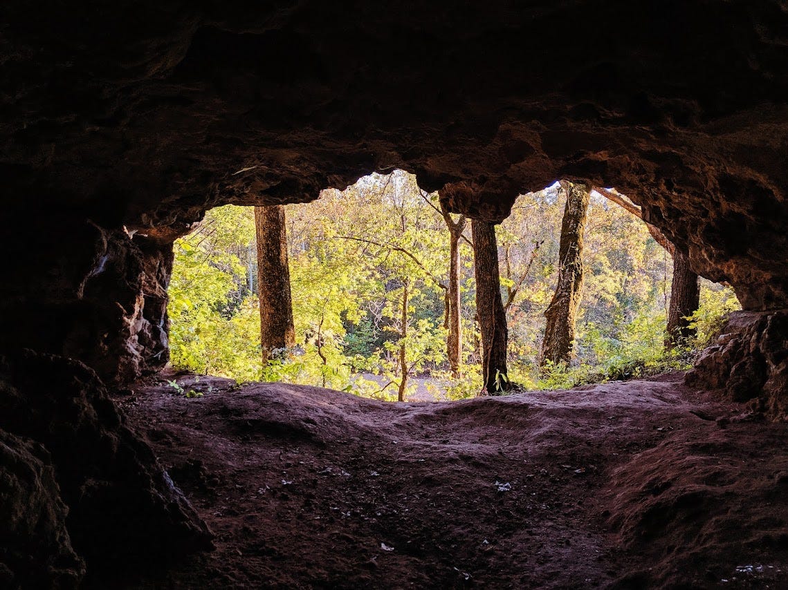
The third and final trail adventure will hopefully take place next month and is a fastpacking trip on the Courtois Section of the Ozark Trail. The OT and I go way back, so I have hiked and backpacked the majority of this section, as it’s the closest part near St. Louis. At 48 miles, this stretch of trail features caves around Onondaga State Park, Courtois Creek crossings, almost half of the Berryman Loop Trail, various streams/ponds, fields of cows near Bass River Resort, and of course the typical wild Missouri wilderness.
Fastpacking is very new to me as I’ve only been on one overnight trip and it wasn’t exactly the best experience. Because I have been trail running more, I figured I would give it another shot. I honestly don’t think I am ready fitness-wise for this kind of adventure, so if for whatever reason I don’t feel confident, I can always safely plan to just backpack the section instead.
This trip is more for the type-2 fun side of me and will certainly be one heck of a challenge. For anyone who doesn’t know, fastpacking is like trail running and backpacking combined. Individuals normally carry a running backpack or vest that is around 15-25 liters and pack the various lightweight gear items for the duration of the trip (tent or bivy, sleeping bag, sleeping pad, etc.).
Since I would be covering 48 miles, it would be impossible for me to bring all my food with me for the entire section (unless I cover more than 20 miles a day, which I am not ready for!), so I am entertaining the idea of food caches or organizing one lucky friend to drop meals and snacks off for me at a different access point along the way. I also still need to figure out the details and assess my physical capabilities, but I think 15 miles each day would be doable. I won’t be running the entire time of course. I will most definitely hike portions of it, so I may be able to go farther than I think. Hopefully, I can complete the section in three or four days; I think that is reasonable.

For now, those are my summer trail plans! I hope to also sneak in little overnights in the Mark Twain National Forest when I can, but overall I just want to try to get outside as much as possible.
Like always, comment, like, or subscribe to stay up to date on hiking content!
See you out on the trail!