


The Eagle Rock Loop
A fun, yet terrifying time on Arkansas's longest loop trail in late spring 2021

This post is all about my trip on the Eagle Rock Loop during May of 2021 and how this 26 mile trail just about killed me in the 25 hours I was on it. Maybe I’m overreacting, maybe I’m exaggerating a bit, but what’s a backpacking trip if you don’t hate the trail at some point or feel like you’re about to die at least half way through? These trips often make the best memories if you’re a type-2 fun addict like myself.
Trail Details
First things first, here’s what you should know about the trail. The Eagle Rock Loop is a rugged, mildly trafficked trail located near Langley, Arkansas inside the Ouachita National Forest. It’s the longest loop trail in Arkansas at a little over 26 miles long connected by three different trails (the Little Missouri Trail, the Athens-Big Fork Trail, and part of the Viles Branch Horse Trail). Because of this, there are a few different trailheads and access points. There are also different colored blazes and signs to look out for when reaching certain parts of the loop.
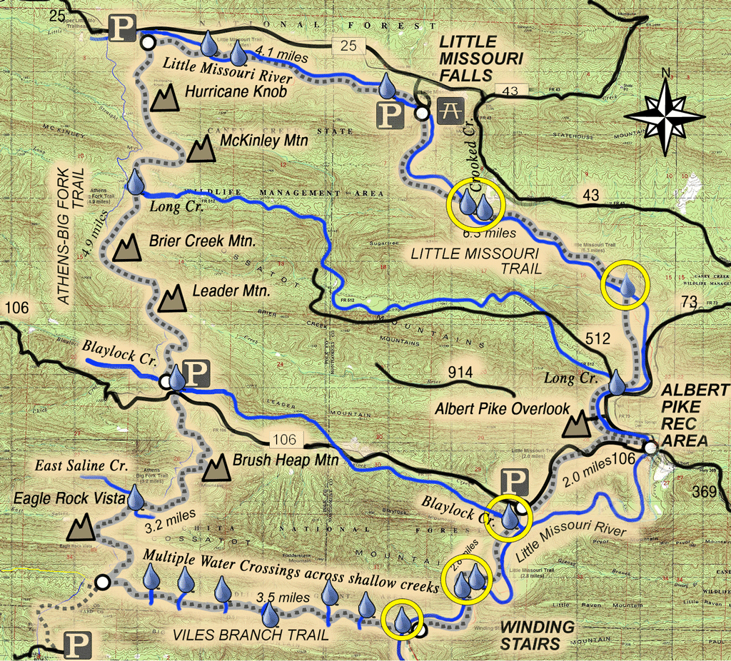
What makes this trail so unique is definitely it’s plentiful water crossings and established campsites. Literally there are tons of them; over fifty campsites scattered throughout the trail according to FarOut as well as a plethora of crossings over the Little Missouri River and even more across creeks. Therefore, I wouldn’t sweat about carrying a lot of water and worrying about where you should camp. There’s no need to be concerned about that on this trail where these resources are abundant (maybe every half mile or so, at least).
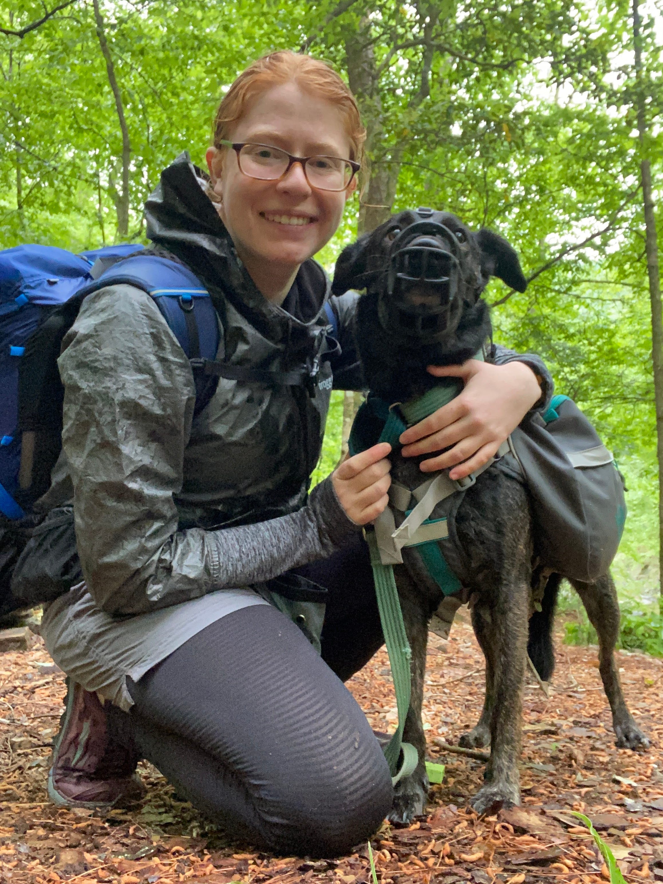
To get there, I consulted trusty Google Maps. I was coming from the St. Louis, Missouri area so it took me about eight hours to get to the trailhead. I spent the night twice in Branson, Missouri (once on the way down, once on the way back) to split up the trip and make it a little more bearable. I was also traveling with my trail queen of a dog, Honey, who gets car sick easily and I knew she would prefer to not be in the car for a super long period of time. If you don’t know the area well or are traveling from out of state like I was, I would highly recommend Google Maps or another GPS device. Depending on which way you come, once you hit Glenwood, Arkansas, cell service disappears.
Day One
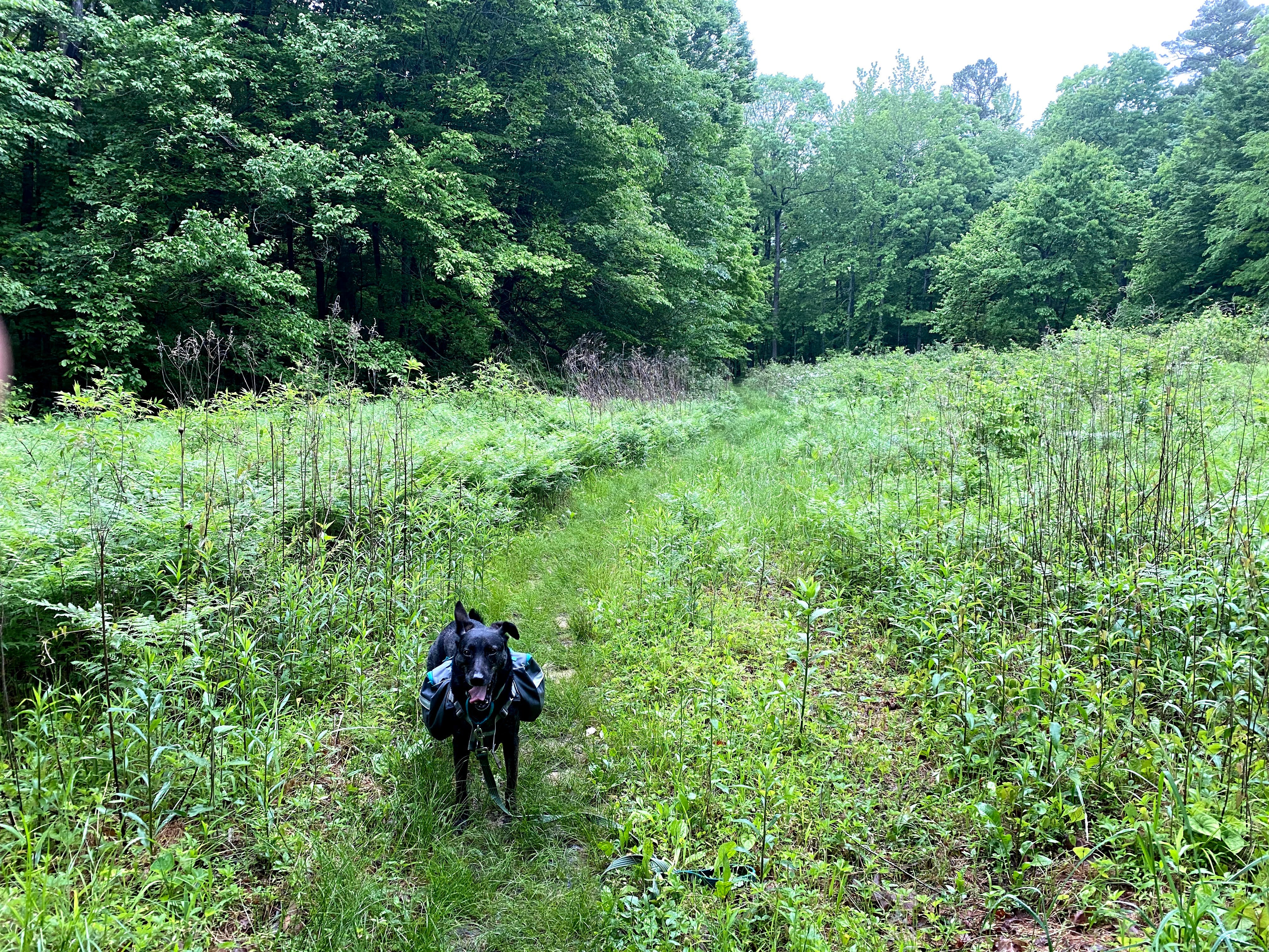
Honey and I reached the Winding Stair trailhead around 2pm and took no time to hit the trail. After being in the car for so long, we were anxious to get going. Before this trip, I had downloaded two maps of the trail which tracked my location (All Trails and FarOut) and right off the bat I started using them to figure out where I was exactly within the loop. There was some confusion at first because of the different colored blazes and not knowing which one I was supposed to follow as well as different water run off trails that intersected the main loop trail, so I ended up getting lost in the first mile. Yet, once I found the legit Eagle Rock Loop, which consisted of white, Appalachian Trail like blazes, it was a piece of cake.
A Brief Theory on Water Crossings
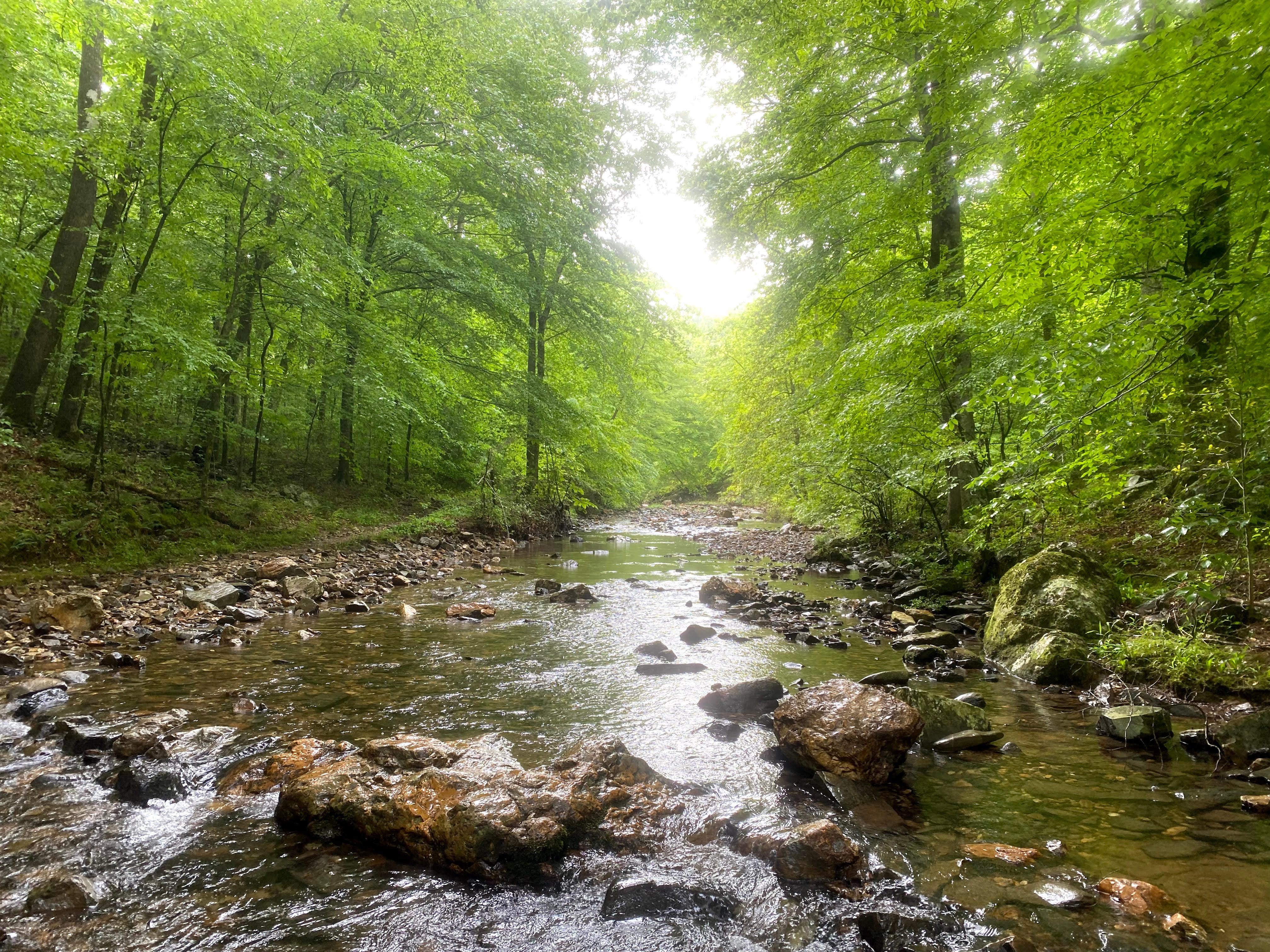
The first Little Missouri River crossing I came upon wasn’t bad and only flowed up to my mid calf. I also decided right then and there that I would most likely be hiking the entire trail without socks. Because of the copious amount of deep water I would have to encounter, especially with it being in the middle of a wet, Midwest spring, I figured there were three options: 1. cross the water without shoes, 2. bring lightweight sandals or water shoes to switch into, or 3. just go sockless in my trail runners.
I ended up choosing the latter because personally, I’ve tried to cross water without shoes and if you’ve never done this before, it flat out sucks. The rocks are slippery, sharp, and can easily cut into your feet or create bruises on the bottom of them. My reluctance to bring sandals is merely laziness and not wanting to waste time repeatedly changing into them at every crossing.
You could argue for waterproof hiking boots as being a viable solution, but at some parts of the trail this wouldn’t be the greatest option because the water could be pretty deep and easily drown a pair of leather mids. Some of the creeks this time of year were ridiculously deep without rocks strategically placed to guide you across. Either way, hike your own hike. I chose the unpopular opinion, but I was happy with my decision and would do it again.
The Downside of Seeking Solitude
As Honey and I continued down the trail, I was swept up in the dense loneliness of this trail. The trees blowing in the wind and whispering to each other, the sound of birds calling out to the world, the bubbling creeks teaming with little fish that slither below my steps, the soft crunch of a dirt path underneath my footfall. I often backpack solo with Honey. A lot of my friends at work and in my personal life think I’m insane for some of the hikes I attempt, so I’m used to being alone and feeling lonely while I’m out in the woods away from other human beings.
To keep my mind occupied, I try to listen to music or podcasts. When that doesn’t help, I normally talk out loud to myself or to Honey or even sing to prevent my mind from wandering too far off into a dark headspace. I’m an introvert by nature, but there’s something remotely chilling about being in the middle of nowhere by myself. If I’m not careful, I can sike myself out and start to get terrified or paranoid.
Real Mountains
The first six miles of trail from my car going clockwise within the loop were relatively flat with beautiful scenes of rock formations following the Little Missouri River. I would cross her a few times before reaching my first climb of many and boy, was it difficult. For someone who is used to hiking in the mountains regularly, this incline wouldn’t be a big deal. However, coming from rolling hills Missouri, for me it was quite the ass kicker. Rising a few hundred feet in elevation over a half mile in theory isn’t that bad. Yet, it took Honey and I a hot minute to make it to the top.
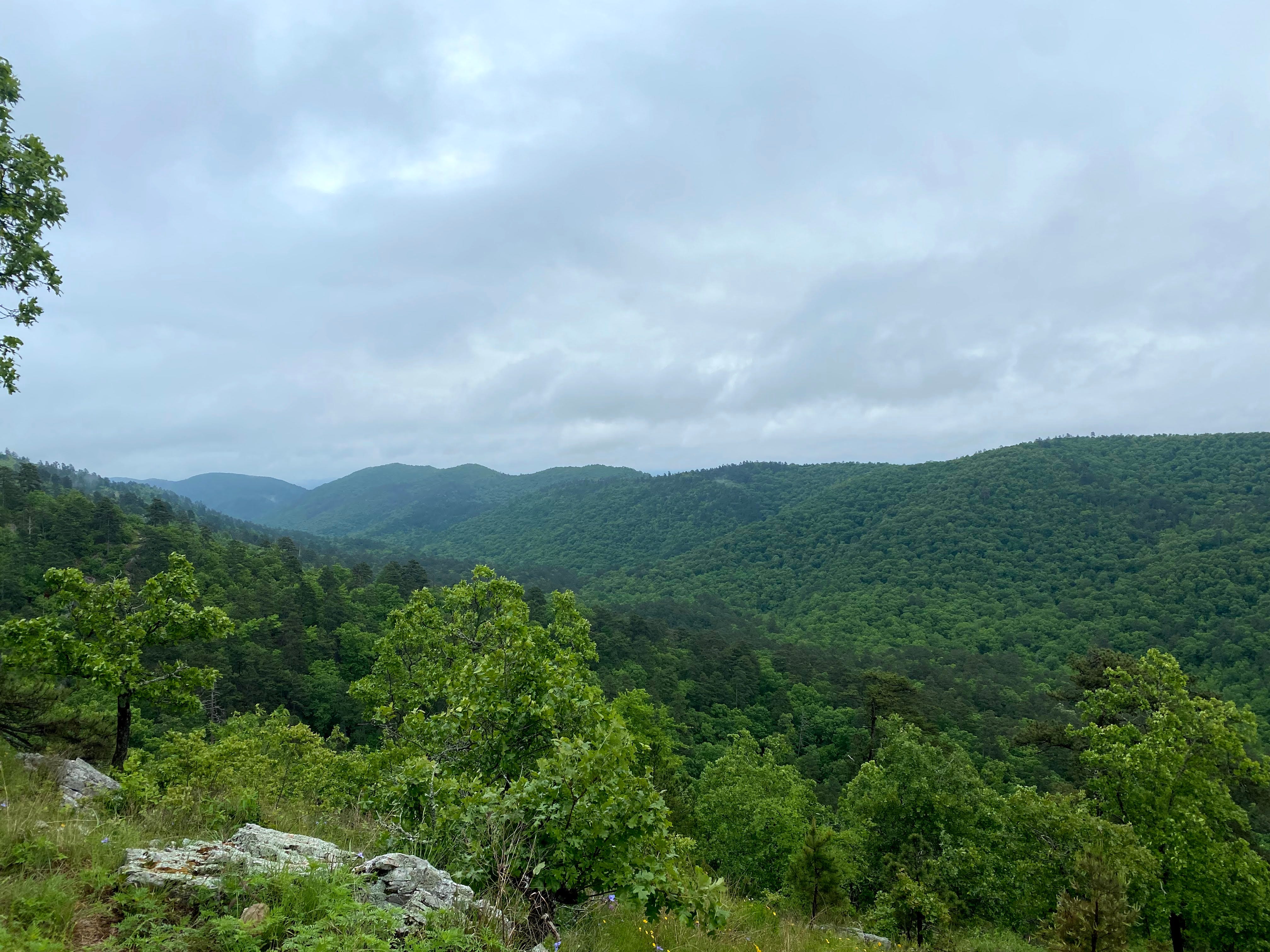
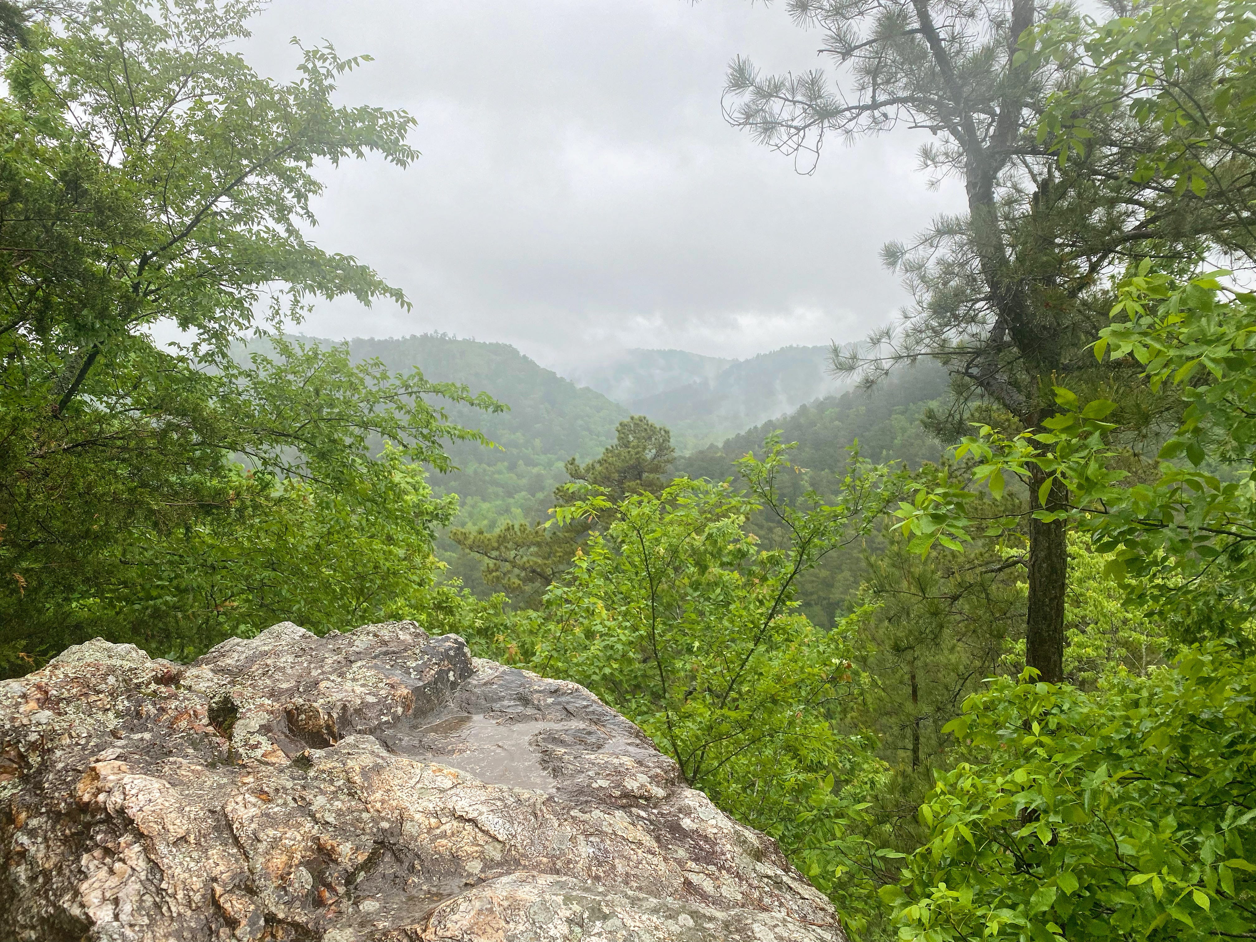
Once there, we were met with the most gorgeous vista overlooking the wild Ouachita Mountain range. By this point, I had a few more roller coaster climbs until I reached my designated campsite for the night and there were only a couple hours of daylight left. I had to get going, but I couldn’t take my eyes off these breathtaking hills. At that moment, I thought about home and missed the people I loved the most.
The next four miles were merely going up and down these godforsaken mountains. By the end of it, I was surely cussing, but inside my heart was happy and full. Honey and I set up camp at the very top of one of the hills just as the sun was falling. From there I went into robot mode: set up the tent, blow up the sleeping pad, unstuff the sleeping bag, boil the water, cook the dinner, eat the gross freeze dried meal, crawl into bed, and plan the next day.
We had traversed ten miles that day, so the goal for the next day would be finishing the trail at a reasonable time, which would mean knocking out 16 miles. The mileage didn’t scare me, but the weather forecast sure did. It was supposed to rain and thunderstorm all day, unfortunately. This didn’t sound like fun, but I was more focused on getting a decent night’s sleep. We would deal with whatever may come tomorrow. As I closed my eyes, the thing I remembered the most were the whippoorwill’s defining call piercing the dark air and smiling a little as I burrowed deeper into my bag.
Day Two
The thunder and rain drizzling on my tent woke Honey and I up throughout the night, but we didn’t actually start moving until 6am. By then, the rain had stopped momentarily, so I swallowed breakfast and broke camp as fast as I could. We were on the trail before 6:30 and ready to knock out the rest of the climbs. Luckily the rain and thunder held off long enough for us to get through the rest of the mountainous section.
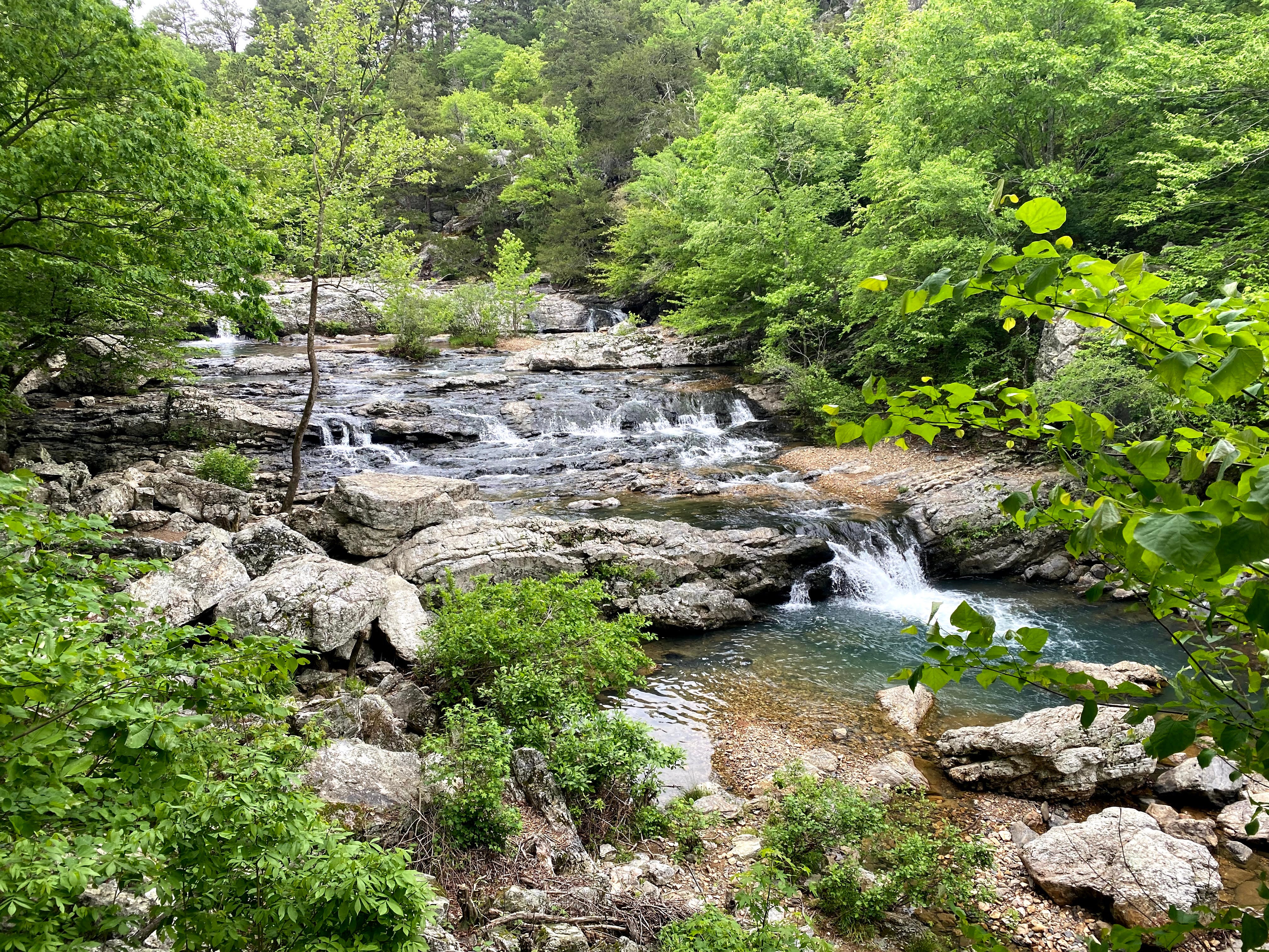
From there, the next 12 miles or so would be sort of flat with a few little inclines here and there. We were making good time and made it to the Little Missouri Falls relatively fast within the day. The water was coursing, flowing strong, and was certainly an iconic part of the Eagle Rock Loop. Honey and I snapped a few pictures, admired the view, and then cruised along. With the storm having not arrived yet, my hope was to make it past the last two river crossings before it started.
Several “Oh, shit” Moments
Of course in typical Callie Hikes fashion, that’s not what happened. The sky broke and down came the rain. I had a rain cover on my pack and a lightweight rain jacket on as well, but within a few minutes I was completely soaked. Honey kept looking up at me like “why are we out here doing this right now?” and I had to admit, I was thinking the same thing. The rain was unforgiving as we crossed the now much higher Little Missouri River and my only thought the entire time was just “go, Go, GO!”
We had about six more miles of this and as we kept going, things got harder. Between the rain pelting us, my glasses getting foggy and blurry, the rugged terrain (which turned into a legit flowing creek), and the confusing side trails, we kept getting lost. I was hesitant to keep checking FarOut or All Trails because I didn’t want my phone to get too wet, so I eventually just trusted my instincts and marched onward. Thank goodness, it was the right direction.
After a long, brutal, drenched, and soggy, six miles, we finally made it back to my car. And the smile on my face was as big as it always gets when I overcome something difficult and finish a trail. Honey and I took our time peeling our packs off our backs and getting cozy with the heater on in our car before we drove away. As we headed towards Branson with a hot shower and massive Qudoba burrito in my future, I reflected on my 25 hours while out on the Eagle Rock Loop.
Closing Thoughts
Despite it being one of the harder trails I’ve completed, I would do the Eagle Rock Loop again. I’d be curious to come back without the possibility of a horrendous thunderstorm; maybe during the fall when the leaves are changing and are in peak autumn bloom. I first heard about this trail from a customer I outfitted at the Alpine Shop. He needed boots for this specific trail and ended up going in October when the weather was cool and crisp. After reading other trip reports and blogs on the internet, I think fall is certainly one of the better times to visit the Ouachita Mountains. The Eagle Rock Loop experience will definitely never be forgotten and is still a fun story to tell even several months later.
Stay tuned for more content and I hope to see you out on the trail!